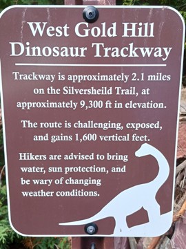
West Gold Hill Dinosaur Trackway
| Trail Features: | History, Scenic Views | 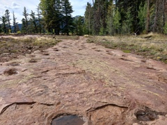 |
|||
| Trail Location: | Silvershield Trailhead | ||||
| Roundtrip Length: | 4.2 Miles | ||||
| Trailhead Elevation: | 7660 Feet | ||||
| Total Elevation Gain: | 1660 Feet | ||||
| Avg. Elev Gain / Mile: | 790 Feet | ||||
| Highest Elevation: | 9311 Feet | ||||
| Trail Difficulty Rating: | 7.52 (moderate) | ||||
| Parking Lot Latitude | 38.03943 | ||||
| Parking Lot Longitude | -107.68218 | ||||
Trail Description:
The West Gold Hill Dinosaur Trackway is arguably one of the most unique hiking destinations you’ll find just about anywhere. What’s truly amazing is that the previous land owner didn’t know they were fossilized dinosaur tracks until 2021. In April of 2024, the Jack Charles family, which had owned this parcel of land since 1945, sold it to the Grand Mesa, Uncompahgre and Gunnison National Forests so that the tracks would be protected indefinitely.
The West Gold Hill Dinosaur Trackway contains 134 consecutive footprints that extend for 106 yards. The site is now recognized as the longest continuous dinosaur trackway in the world. The pothole-like tracks in sandstone layers were made by a single long-neck sauropod dinosaur over 150 million years ago. Because of the Charles family's foresight and consideration, the site is now open to the public.
 The hike to the trackway begins from the Silvershield Trailhead in Ouray. To reach the trailhead from the heart of downtown Ouray, you should turn to drive westbound on 7th avenue. At the end of the road, take a right onto Oak Street and drive almost 1.2 miles. Look for a small street sign that indicates the Silver Shield Trail. Turn left here, and the parking area will be located straight ahead.
After pulling into the parking lot you’ll be staring directly at an imposing wall of that forms the eastern slopes of Whitehouse Mountain rising above the valley floor. At this point, you may be asking yourself in which direction does the trail go, and how exactly are you going to be able to make it to the top of the ridge. It looks pretty daunting from this vantage point. No doubt, from the start, the trail climbs sharply. However, as you ascend you’ll immediately begin to enjoy views of the Ouray Valley.
During this stretch, and others further up the mountain, there’s some exposure to steep drop-offs, but nothing I would consider to be exceedingly dangerous. However, you will be exposed to the sun as it rises above the mountains on the east side of town. During the summer months you’ll probably want to start your hike as early in the morning as possible to take advantage of the shade these mountains provide.
At three-tenths of a mile from the trailhead hikers will arrive at an overlook of Gold Hill across the valley. Located here are a memorial and a bench if you need a break from the steep climbing. Also located here is a plaque containing information on the mining history in this area. If you look closely, you’ll notice several old mining buildings on Gold Hill, and maybe even a few shafts.
At just under 1.1 miles you’ll reach the Oak Creek Trail junction. Hikers should take a left here to continue along the Silvershield Trail towards the dinosaur tracks. At this point you will have already climbed roughly one thousand feet.
At just over 1.6 miles hikers will pass the ruins of an old miner’s cabin. Beyond the cabin be sure to use caution as you traverse along the edge of another steep precipice.
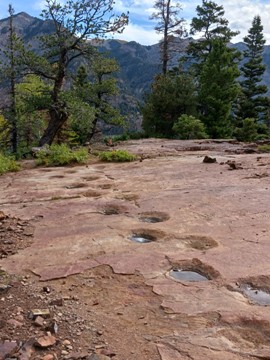
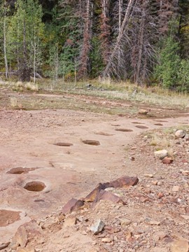
At roughly 2.1 miles hikers will finally reach the dinosaur tracks. Depending on your timing, these fossilized footprints may be filled with rain water, which actually makes them standout a little better. The trail first arrives at the apex of the U-turn the dinosaur famously made as it passed through this area. Apparently, a full turnaround like this is highly unusual among other dinosaur tracks found in other parts of the world. Why did this massive creature make this turn?
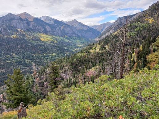
From here you can explore the tracks as they proceed in two directions. I would also encourage you to walk another 150 yards or so beyond the tracks to an overlook that provides outstanding views of the surrounding mountains, as well as the Million Dollar Highway and the Camp Bird Road valley.
Additional Resources:
* Grand Mesa, Uncompahgre and Gunnison (GMUG) National Forests
* Trails Illustrated Map for Telluride, Silverton, Ouray and Lake City areas