Ypsilon Lake
| Trail Features: | Lake Views, Waterfalls | 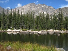 |
|||
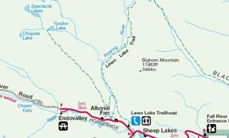
| Trail Location: | Lawn Lake Trailhead | ||||
| Roundtrip Length: | 9.0 Miles | ||||
| Trailhead Elevation: | 8540 Feet | ||||
| Total Elevation Gain: | 2380 Feet | ||||
| Avg. Elev Gain / Mile: | 529 Feet | ||||
| Highest Elevation: | 10,740 Feet | ||||
| Trail Difficulty Rating: | 13.76 (strenuous) | ||||
| Parking Lot Latitude | 40.40712 | ||||
| Parking Lot Longitude | -105.62669 | ||||
Trail Description:
The hike to Ypsilon Lake in Rocky Mountain National Park begins from the Lawn Lake Trailhead in the Horseshoe Park area, located just west of Estes Park. To reach the trailhead drive 2.1 miles past the Fall River Entrance Station on Highway 34 and turn right onto Old Fall River Road. The trailhead is located one-tenth of a mile from this junction along the north side of the road.
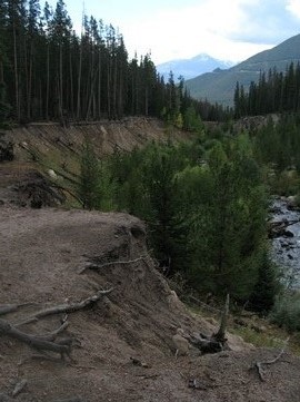
 Hikers visiting Ypsilon Lake and Lawn Lake will share the same path during the first 1.4 miles of this hike. Portions of this stretch of trail were heavily damaged during the September 2013 Flood. However, these sections were repaired by crews in 2016 and 2017, including the footbridge that spanned the Roaring River.
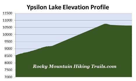
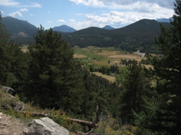
From the beginning the trail climbs steadily through a fairly dense pine forest. Over the course of the first two miles or so you'll catch sporadic views of Deer Mountain, Longs Peak and the other mountains that surround the Horseshoe Park and Endovalley areas.
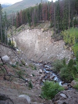
At just over a mile from the trailhead hikers will reach the steep banks of the Roaring River where you'll witness some of the destruction from the infamous Lawn Lake Flood. In 1903 a 26-foot high earthen dam was built to enhance the natural lake from 16.4 acres to 48 acres in order to help with crop irrigation in the Loveland area. On July 15, 1982, the dam failed and released more than 300 million gallons of water down the Roaring River valley. Some witnesses said the failure created a wall of water 25 to 30 feet high. After killing three campers the water rushed down Elkhorn Avenue in Estes Park before stopping at Lake Estes. In all, damages to the area totaled roughly $31 million. Even today sections of the Roaring River's high gully walls remain unstable and prone to sudden collapse. The dam failure led to the removal of three other man-made dams within the park, including Pear Lake, Sandbeach Lake and Bluebird Lake.
At roughly 1.4 miles from the trailhead hikers will arrive at the Ypsilon Lake Trail junction. Hikers should turn left here to continue towards Ypsilon Lake. The main trail continues towards Lawn Lake.
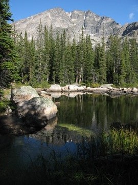
At just over 3.5 miles the trail finally flattens out, while also reaching its highest elevation of roughly 10,740 feet. After descending a short distance you'll reach a very beautiful pond known as Chipmunk Lake (see photo below, on left), which I found to be far more scenic than Ypsilon Lake. From its shore you'll enjoy outstanding views of Ypsilon Mountain, including the snow-filled Y-looking couloir from which the mountain derives its name.
After passing Chipmunk Lake the trail begins descending again, including a fairly steep decent just before reaching Ypsilon Lake. At 4.2 miles hikers will pass the Upper Chipmunk Backcountry Campground, and at 4.5 miles, will finally arrive along the western shore of Ypsilon Lake. For the best views of the surrounding mountains hikers should take the social trail that leads east towards the opposite end of the lake.
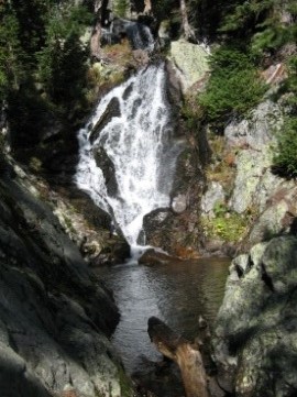
Ypsilon Lake sits at the base of 13,514-foot Ypsilon Mountain and 13,069-foot Mt. Chiquita in the heart of the Mummy Range, and is fed by a waterfall near the point where the trail intersects with the lake.

For the adventurous - those with basic scrambling and route-finding skills - it's possible to continue along a social trail that leads west from the inlet creek, to a couple of alpine lakes known as Spectacle Lakes. The two lakes fill a cirque basin just beneath Ypsilon Mountain.