Aspenglen Loop
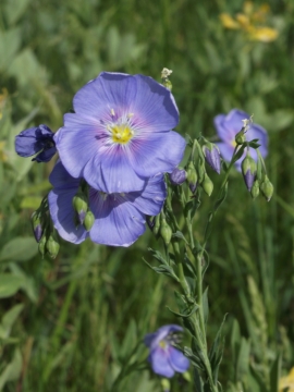
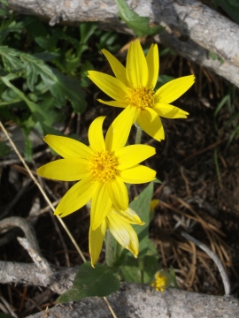
| Trail Features: | Mountain Views, Wildlife, Wildflowers | 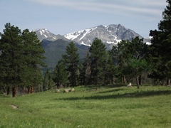 |
|||
| Trail Location: | Aspenglen Campground | ||||
| Roundtrip Length: | 3.0 Miles | ||||
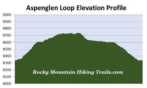
| Trailhead Elevation: | 8339 Feet | ||||
| Total Elevation Gain: | 425 Feet | ||||
| Avg. Elev Gain / Mile: | 283 Feet | ||||
| Highest Elevation: | 8738 Feet | ||||
| Trail Difficulty Rating: | 3.85 (easy) | ||||
| Parking Lot Latitude | 40.40206 | ||||
| Parking Lot Longitude | -105.59665 | ||||
Trail Description:
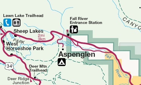
The Aspenglen Loop hike in Rocky Mountain National Park begins from the Aspenglen Campground, located just past the Fall River Pass Entrance. Almost immediately after entering the park turn left into the campground and drive two-tenths of a mile to a small parking area next to the bridge over Fall River. There's room for two or three cars on the left side of the road, and maybe one spot on the right. Although the trailhead isn't marked, there is a wayside exhibit that discusses the Lawn Lake Flood.
From the parking area the trail immediately crosses over Fall River along the west side of the bridge. During the summer season this is primarily a horse trail, but is used by hikers throughout the year.
After traveling one-tenth of a mile hikers will reach the loop portion of the hike. Although you can continue in either direction, we turned left to proceed in a clockwise direction. From the junction the trail begins a moderate climb through a montane forest of grassy meadows and ponderosa pine. During our late-spring hike we saw a wide variety of wildflowers throughout the entire route. We also saw quite a bit of wildlife, including a lone turkey, a woodpecker, mountain bluebirds, hummingbirds, barn swallows and many other songbirds. This area is also prime habitat for deer and elk.
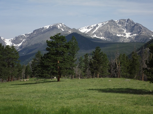
 As you proceed higher along this first section you'll enjoy outstanding views of Deer Mountain, which dominates the landscape towards the southeast. Hikers should note that there are many sections throughout the loop where you'll have to contend with horse manure along the path, especially during the summer season. During the off season, however, it won't be as bad.
At roughly nine-tenths of a mile, after skirting around the northwestern slopes of Deer Mountain, hikers will reach the spur trail that leads to the North Deer Mountain Trail and Deer Ridge Junction. As an alternative, if you wish to avoid trails with the heaviest horse traffic, you'll have the option of visiting Little Horseshoe Park from Deer Ridge Junction, which travels along some of the same paths, and offers similar scenery as this loop hike. To continue on this hike you should proceed straight ahead at this junction to proceed towards Horseshoe Park. Although none of the trails along this route have specific names, the loop itself is well marked by trail signs at every junction.
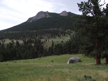
From the junction the trail passes along the edge of a large grassy meadow known as Little Horseshoe Park. Eventually you'll begin enjoying outstanding views of the Mummy Range, including 13,514-foot Ypsilon Mountain. At roughly 1.1 miles you'll reach a spur trail that provides a shortcut if you wish to shorten your hike. To continue on the main loop you should proceed straight ahead at this junction.
At roughly 1.4 miles hikers will pass near an old park building, and at just over 1.5 miles you'll reach a dirt service road. To continue on the loop you should turn right here. The loop trail branches off the dirt road after walking roughly 25 yards. After turning right onto the loop and walking another 25 yards or so, the trail will reach another junction. The footpath leading towards the left is the Little Horseshoe Park Trail. To stay on the loop you should turn right here.
At just over 1.9 miles you'll pass the lower shortcut trail junction. You should stay to the left here to continue on the loop. Throughout this section of the hike you'll pass through a broad meadow that offers sweeping views of the Mummy Range, including Mt. Chapin, Mt. Chiquita and Ypsilon Mountain.
You'll know you're nearing the end of the loop when you begin to hear the roar of Fall River crashing down the valley floor. At roughly 2.9 miles you'll reach the end of the loop portion of the hike. Simply turn left to return back to the trailhead. Despite the large amounts of horse manure in many areas, we both thought this was an outstanding hike for the quiet and solitude, the wildflowers and wildlife, as well as some of the outstanding views along the route.