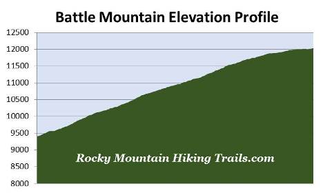
Battle Mountain
| Trail Features: | Outstanding Views, Fall Aspens | 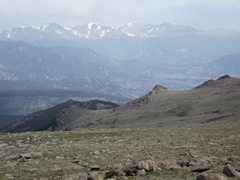 |
|||
| Trail Location: | Longs Peak Ranger Station | ||||
| Roundtrip Length: | 9.7 Miles | ||||
| Trailhead Elevation: | 9405 Feet | ||||
| Total Elevation Gain: | 2639 Feet | ||||
| Avg. Elev Gain / Mile: | 544 Feet | ||||
| Highest Elevation: | 12,044 Feet | ||||
| Trail Difficulty Rating: | 14.98 (strenuous) | ||||
| Parking Lot Latitude | 40.27215 | ||||
| Parking Lot Longitude | -105.55682 | ||||
Trail Description:
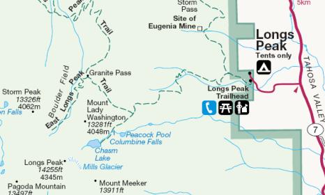
The hike to Battle Mountain in Rocky Mountain National Park begins from the Longs Peak Trailhead. To reach the trailhead from Estes Park, drive 8.9 miles south along Colorado Highway 7 to the turnoff for the Longs Peak Ranger Station. From the turnoff drive another mile to the ranger station. Please note that parking is fairly limited, and the lot fills up very early on weekends. Additional parking is available along the roadside leading up to the trailhead, but is also quite limited. You should also want to note that car-camping isn't allowed in the parking area.
Due to the popularity of the hikes from this trailhead, the length of time to reach most destinations, exposure to afternoon thunderstorms, and limited parking, you'll definitely want to arrive as early in the morning as possible, especially on weekends during the summer months. Day hikers planning to summit Longs Peak usually arrive between 3 a.m. and 5 a.m.
Starting at an elevation of roughly 9405 feet, hikers will be following the East Longs Peak Trail for the majority of this hike. However, because the last half-mile travels off-trail, hikers should be comfortable with boulder hopping and some minor route finding before attempting this hike.
From the Longs Peak Ranger Station the trail begins a steep climb through a thick forest of lodgepole pine, spruce and fir. Roughly one-half mile from the trailhead hikers will reach the Eugenia Mine Trail junction, and at 1.2 miles will pass the short side trail that leads to the Goblins Forest Backcountry Campground (containing six individual campsites).
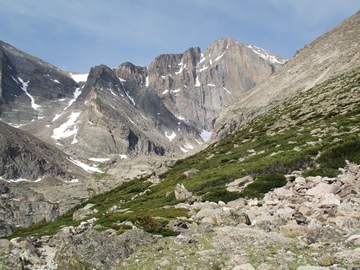 At 2.2 miles from the trailhead, and an elevation of roughly 10,750 feet, hikers will emerge from the forest and enter the subalpine zone. Dominating the landscape along this stretch of trail is krummholz, a German word that means twisted wood, which describes the stunted and irregular growth patterns of trees found in the transition zone between forest and tundra. Mt. Meeker, Longs Peak and Mt. Lady Washington will come into view at this point as well.
Longs Peak is the highest point in Rocky Mountain National Park. The 14,259-foot peak is named after Major Stephen H. Long who led an expedition across the Great Plains and along the base of the Rockies in 1820. While out on the plains, in the distant view, the expedition could see the highest mountain in the northern range. Although they never entered Rocky Mountain National Park, three members of the expedition would later become the first to climb Pikes Peak.
 John Wesley Powell, along with several others including William Byers, the founder of Rocky Mountain News, made the first ascent of Longs Peak in 1868. Powell, the one-arm Civil War General, was also the first person to float the Colorado River through the Grand Canyon.
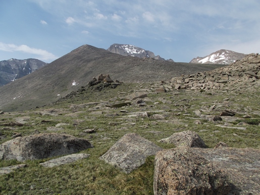
At just over 2.5 miles hikers will reach the spur trail that leads to the Battle Mountain Backcountry Campsite (contains one group campsite). From this junction you'll be able to see your destination. Looking straight ahead from this point is Granite Pass, the lowest point on the horizon, with Battle Mountain extending off towards the right (see photo on the left).
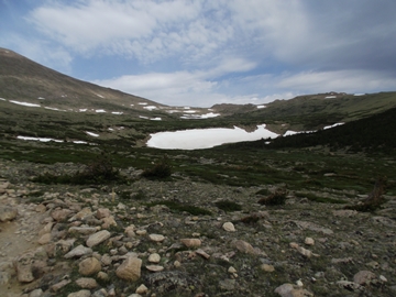
Beyond the junction the main trail leaves the subalpine zone and begins to ascend Mills Moraine. During our most recent late-spring hike we saw a wide variety of alpine wildflowers as we climbed higher into the tundra zone. Most hikers will likely benefit from the use of trekking poles as they travel along this rugged stretch of terrain.
At roughly 3.4 miles, and an elevation of 11,540 feet, hikers will arrive at the Chasm Lake Trail junction. From this point 13,281-foot Mt. Lady Washington will be the dominating feature towards the west. Beyond the junction the trail traverses along the northeastern slopes of Mt. Lady Washington as it makes its way towards Granite Pass. During this stretch Battle Mountain will dominate the views towards the north.
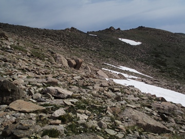 At roughly 4.4 miles from the trailhead, and an elevation of 11,960 feet, we left the main trail and began heading towards Battle Mountain. At this point we were roughly one-tenth of a mile from the pass. Our route took us around the large mound of rocks that form the northern side of Granite Pass, while maintaining the same elevation to reach the flat ridge atop Battle Mountain. You'll have the option of continuing through Granite Pass to reach North Longs Peak Trail, and then ascending Battle Mountain from the west. Although this route may be a little easier, it will be a little longer in length. Either way you'll need to be comfortable with some boulder hopping and a little bit of route finding for almost a half mile. Your destination, however, is perfectly clear. As you proceed along this off-trail stretch you should try to stay on rocks and boulders as much as possible in order to minimize the impact on sensitive tundra plants and terrain.
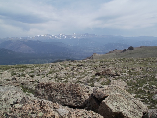
As mentioned, from the main trail, we tried to maintain our elevation as we skirted around the first rock outcropping while trying to reach the level ground that prevails along the top of the long ridge. Although the first quarter-mile is fairly rugged, once beyond this stretch travel became fairly easy. We climbed the second rock outcropping to gain outstanding views of the surrounding mountains. Looking towards the south Mount Lady Washington dominated the view. Depending on where you're standing, you'll also be able to see Mt. Meeker, Longs Peak and Storm Peak towards the south and southwest. Towards the northwest you'll enjoy commanding views of the Boulder Brook Basin and the mountains that form the Mummy Range and the Continental Divide. As you can tell from my photos we had a fairly hazy day due to clouds and smoke from wildfires in the region:
The national park website provides additional information on hiking in the Longs Peak area, as well as general hazards you should be aware of while hiking in the high country.