
Bilk Basin Overlook
| Trail Features: | Outstanding Panoramic Views | 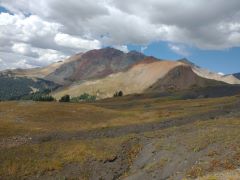 |
|||
| Trail Location: | Cross Mountain Trailhead (near Telluride) | ||||
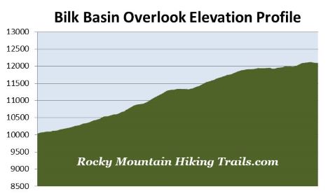
| Roundtrip Length: | 7.7 Miles | ||||
| Trailhead Elevation: | 10,040 Feet | ||||
| Total Elevation Gain: | 2105 Feet | ||||
| Avg. Elev Gain / Mile: | 547 Feet | ||||
| Highest Elevation: | 12,120 Feet | ||||
| Trail Difficulty Rating: | 11.91 (strenuous) | ||||
| Parking Lot Latitude | 37.79643 | ||||
| Parking Lot Longitude | -107.93744 | ||||
Trail Description:
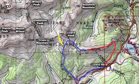
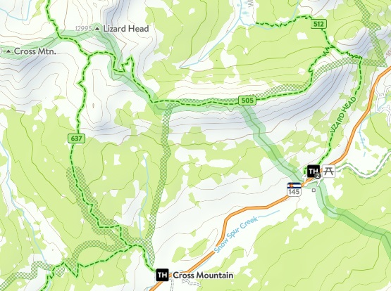
The hike to the Bilk Basin Overlook begins from the Cross Mountain Trailhead, located roughly 1.9 miles south of Lizard Head Pass, or 13.9 miles south of the traffic circle near Telluride on CO 145. The parking area for the trailhead is located just off the highway.
From the trailhead hikers will almost immediately cross over Snow Spur Creek. 12,147-foot Black Face Mountain will be off to your right, while 13,176-foot Sheep Mountain rises directly behind you. After a short distance the trail crosses over an unmarked and barely discernable railroad bed. This is the return route used by those wishing to create a loop hike. Soon afterwards the Lizard Head briefly comes into view for the first time as well.
At just under six-tenths of a mile hikers will arrive at the Groundhog Stock Trail junction. You should proceed towards the right to continue along Cross Mountain Trail. Just above the junction the trail begins to ascend through a pleasant spruce forest.
At just over 2 miles hikers will pass the Lizard Head Wilderness boundary marker. After walking another eight-tenths of a mile you’ll emerge from the forest for the last time. From this point forward you’ll enjoy unobstructed views of Lizard Head Peak. Spectacular vistas of 12,700-foot Cross Mountain and 14,246-foot Mt. Wilson also come into view here.
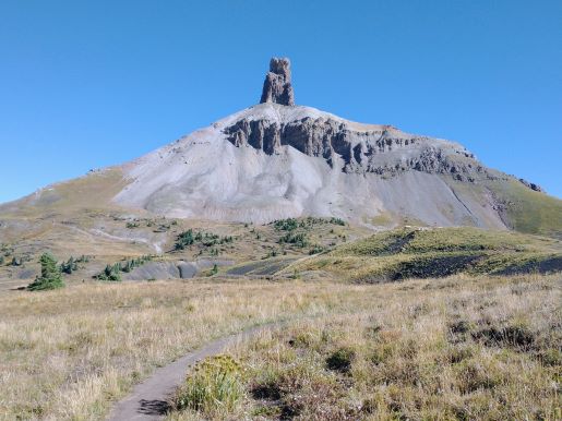
At roughly 3.1 miles you’ll finally reach the top of the climb. The trail then circles around a bend to reach a grassy basin below the southern slopes of Lizard Head Peak where you’ll enjoy an impressive up-close view of the 13,113-foot mountain. Lizard Head Peak is topped by a 400-foot volcanic spire of rotten, crumbling rock that, according to the San Juan National Forest website, has been voted as one of Colorado's most dangerous and difficult climbs. As you continue toward the highly iconic mountain you may notice Mt. Sneffels in the far off distance on your right.
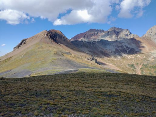
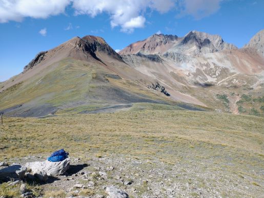
At 3.5 miles hikers will arrive at the Lizard Head Trail junction. To proceed towards Bilk Basin Overlook you should turn left here and walk almost another four-tenths of a mile. Although there aren’t any signs indicating the exact location of the overlook, there is a wood post that represents the endpoint for this hike. Near the post is a rock outcropping that offers a great place to relax and soak-in the absolutely stunning views that dominate here. Rising above the basin are the rugged mountains of the San Miguel Range. From left to right you’ll enjoy a front row view of Mount Wilson, 13,913-foot Gladstone Peak and 14,017-foot Wilson Peak.
If you have the time and energy, and the weather is cooperating, I highly recommend returning back to the Cross Mountain Trail junction and then continuing eastbound along the Lizard Head Trail. After walking roughly four-tenths of a mile you’ll arrive at the saddle along the southeast ridge of Lizard Head Peak. The trail actually passes just below the saddle. Simply walk up to the top where you’ll enjoy an absolutely spectacular 360-degree view. Although this section of trail is mostly flat, you will have some exposure to steep drop-offs in a few places where the trail becomes quite narrow.
As previously mentioned, hikers can create a spectacular loop by combining the Cross Mountain Trail with the Lizard Head Trail as it crosses over Black Face Mountain, before heading down to Lizard Head Pass. Hikers will then use the old railroad bed, which effectively parallels the highway, to complete the loop. This route is roughly 12.2 miles in length, and includes roughly 2700 feet in total elevation gain.
Hikers should always be aware of lightning risk while hiking in the Rocky Mountains, especially at higher elevations. As a general rule of thumb you should plan to be off the summit before noon in order to avoid the notorious afternoon thunderstorms that frequent the mountains during the summer months. Hikers should also be prepared for extreme sun exposure, wind, cool temperatures, and rapidly changing weather conditions while on the trail. Make sure you have the proper gear with you, and know what safety precautions you need to consider beforehand.