Black Lake
| Trail Features: | Outstanding Views, Alpine Lake, Waterfalls | 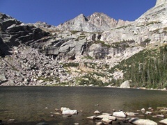 |
|||
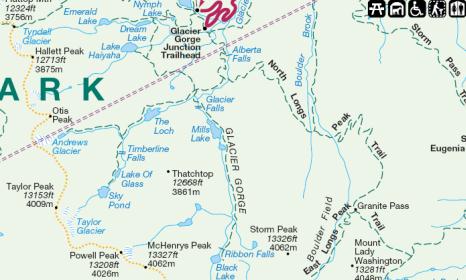
| Trail Location: | Glacier Gorge | ||||
| Roundtrip Length: | 9.6 Miles | ||||
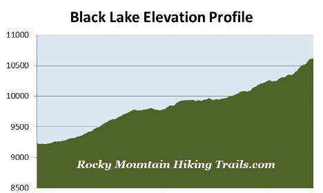
| Trailhead Elevation: | 9240 Feet | ||||
| Total Elevation Gain: | 1480 Feet | ||||
| Avg. Elev Gain / Mile: | 308 Feet | ||||
| Highest Elevation: | 10,620 Feet | ||||
| Trail Difficulty Rating: | 12.56 (strenuous) | ||||
| Parking Lot Latitude | 40.31035 | ||||
| Parking Lot Longitude | -105.64038 | ||||
Trail Description:
The hike to Black Lake in Rocky Mountain National Park begins from the Glacier Gorge Trailhead, located on Bear Lake Road almost 8 miles from the turn-off at Highway 36. Due to the extreme popularity of the Bear Lake Road area you may want to consider using the free park shuttle to access the trailhead during peak tourist season. Hikers will also have the option of starting their hike from the Bear Lake Trailhead. This will add another two-tenths of a mile to your overall roundtrip mileage.
Roughly one-quarter of a mile from the parking area, just after crossing Chaos Creek, the trail briefly converges with the Glacier Creek Trail. After walking a very short distance the Glacier Creek Trail splits off to the right and heads toward Bear Lake. To continue on towards Black Lake hikers should turn left at this junction.
At just over eight-tenths of a mile hikers will reach Alberta Falls, one of the more popular hiking destinations in the park. This scenic 30-foot waterfall thunders down a small gorge on Glacier Creek, and is named after Alberta Sprague, the wife of Abner Sprague, one of the original settlers in the Estes Park area.
The next section of trail, between Alberta Falls and Mills Junction, was rehabilitated by the National Park Service and the Rocky Mountain Conservancy as part of a major, multi-year project that was completed in 2012.
At 1.6 miles hikers will arrive at the North Longs Peak Trail junction. To continue on towards your destination hikers should turn right here.
About a half-mile further up the trail you'll reach Mills Junction. Straight ahead is the Loch Vale Trail which leads to Sky Pond, while the side trail to the right leads to Lake Haiyaha. As part of the same trail rehabilitation project, this unimproved route was also upgraded in an effort to make it safer and easier to follow as it travels towards the lake.
 To continue on towards Black Lake hikers should turn left at this junction. After a short distance the trail crosses over Vale Brook, at which point you'll enter the majestic Glacier Gorge.
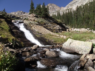
At 2.4 miles you'll cross over Glacier Creek. Just before crossing the footbridge you might notice a faint social trail on your right. After walking roughly 40 yards along this path you'll reach the base of a small waterfall known as Glacier Falls.
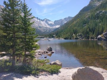
At just over 2.6 miles hikers will reach the foot of Mills Lake, a beautiful subalpine lake nestled below Half Mountain. From its eastern shore, looking from left to right, you'll have outstanding views of the Keyboard of the Winds, 13,497-foot Pagoda Mountain, 13,579-foot Chiefs Head Peak and 12,668-foot Thatchtop Mountain. A fairly large rocky area along the edge of the lake makes this a great location for a picnic.
The lake is named after Enos Mills, the man commonly referred to as the "father of Rocky Mountain National Park". Mills spent numerous years lecturing across the nation, lobbying Congress, and writing thousands of letters and articles that eventually led to the creation of Rocky Mountain National Park in 1915.
From the north shore the trail skirts around the east side of the lake, and provides even better photo opportunities, in my opinion. At 3.1 miles you'll reach Jewel Lake with an even more impressive mountain backdrop for photographers.
In between the two lakes, as well as above Jewel Lake, the trail passes over several marshy areas with the help of a series of wooden bridges. This appears to be ideal moose habitat, so you may want to keep an eye out as you pass through this area.
 At just over 3.5 miles hikers will pass a side trail that leads to the Glacier Gorge Campground. By this point you will have already noticed numerous dead trees lying on the ground in this area. In November of 2011 a microburst, with winds estimated at 70 to 90 mph, hit the region and decimated hundreds of trees in this area alone. The blowdown impacted a section of trail that extends for roughly a half-mile, and made route finding a bit of a challenge for hikers during the 2012 season.
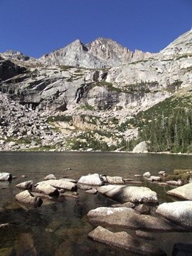
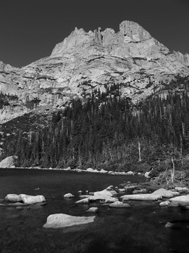
At just over 4.6 miles the trail reaches a small meadow where Ribbon Falls comes into view. From here the trail climbs up the eastern flank of the waterfall. After walking another short distance you'll finally arrive at the foot of Black Lake, located roughly 4.8 miles from the trailhead.
This spectacular alpine lake fills a deep cirque basin carved out of the base of McHenrys Peak and Chiefs Head Peak. From the north shore The Arrowhead will be the dominating feature off to your right. Almost directly in front of you will be 13,327-foot McHenrys Peak, and above the headwall, looking due south, is The Spearhead and 13,579-foot Chiefs Head Peak.
From the foot of the lake the trail continues off towards the left, and eventually leads to a couple of unmaintained social trails that lead to Blue Lake, Green Lake and Frozen Lake.