Lawn Lake
| Trail Features: | Subalpine Lake, Outstanding Views | 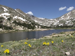 |
|||
| Trail Location: | Lawn Lake Trailhead | ||||
| Roundtrip Length: | 12.6 Miles | ||||
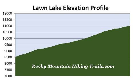
| Trailhead Elevation: | 8540 Feet | ||||
| Total Elevation Gain: | 2490 Feet | ||||
| Avg. Elev Gain / Mile: | 395 Feet | ||||
| Highest Elevation: | 11,006 Feet | ||||
| Trail Difficulty Rating: | 17.58 (strenuous) | ||||
| Parking Lot Latitude | 40.40712 | ||||
| Parking Lot Longitude | -105.62669 | ||||
Trail Description:
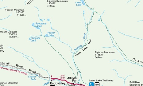
The hike to Lawn Lake in Rocky Mountain National Park begins from the Lawn Lake Trailhead in the Horseshoe Park area, located just west of Estes Park. To reach the trailhead, drive 2.1 miles past the Fall River Entrance Station on Highway 34 and turn right onto Old Fall River Road. The trailhead is located one-tenth of a mile from this junction along the north side of the road.
 Hikers visiting Ypsilon Lake and Lawn Lake will share the same path during the first 1.4 miles of this hike. Portions along this stretch were heavily damaged during the September 2013 Flood. However, these sections were repaired by crews in 2016 and 2017, which includes a new footbridge spanning the Roaring River.
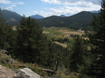
From the start the trail climbs steadily through a fairly dense mixed pine forest. Over the course of the first mile you'll catch sporadic views of Deer Mountain, Longs Peak, Mount Meeker and some of the other mountains that surround the Horseshoe Park and Endovalley areas.
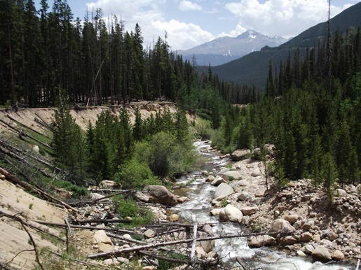
At just over a mile from the trailhead hikers will reach the steep banks of the Roaring River where you'll witness some of the destruction from the infamous Lawn Lake Flood. In 1903, a 26-foot high earthen dam was built to enhance the natural lake from 16.4 acres to 48 acres in order to help with crop irrigation in the Loveland area. On July 15, 1982, the dam failed and released more than 300 million gallons of water down the Roaring River valley. Some witnesses claim the failure created a wall of water 25 to 30 feet high. After killing three campers, the water rushed down Elkhorn Avenue in Estes Park before stopping at Lake Estes. In all, damages to the area totaled roughly $31 million. Even today sections of the Roaring River's high gully walls remain unstable and prone to sudden collapse. The dam failure led to the removal of three other man-made dams within the park, including Pear Lake, Sandbeach Lake and Bluebird Lake.
At roughly 1.4 miles from the trailhead hikers will arrive at the Ypsilon Lake Trail junction. Hikers should veer to the right to continue towards Lawn Lake.
Just before and after the trail split there are four sections of trail that were repaired or rerouted due to the 2013 flood. You likely won't notice any of the changes, as National Park crews did a great job of blending the new sections in with the old. As you travel beyond the split the trail passes through a pleasant forest of lodgepole pine and aspen. During our late-spring hike this section of trail was littered with heartleaf arnica and golden banner. We also passed a fairly long stretch where there were literally hundreds of logs that had amassed along the riverbank from the most recent flood.
At roughly 2.25 miles the trail reaches a sharp switchback and begins to climb again, while moving away from the river. At just over 2.8 miles you'll pass the Cutbank and Golden Banner Backcountry Campsites. As you climb above these two campsites you'll begin to enjoy sporadic views of the Mummy Mountains. Though the distance might be a little long, there really aren’t any difficult sections on this hike. Most of the climbing is fairly moderate.
At roughly 5.75 miles hikers will reach the Black Canyon Trail junction. You should proceed straight ahead to continue towards Lawn Lake. Once past this junction the trail skirts around an extensive boulder field that was created by the dam burst. At roughly 6.3 miles hikers will finally reach the subalpine lake. I would recommend continuing for another tenth-of-a-mile or so to reach a large beach area. This is a great place to park for a long while and soak in the scenic sights. This beach area was actually created after the dam was constructed, and the lake levels rose to the current grass line.
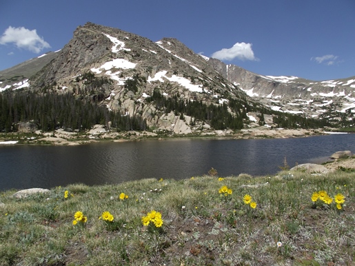
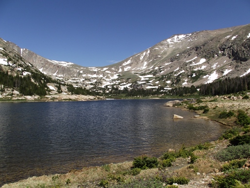
As you can see the views from the lake are simply outstanding. The mountain dominating the scene directly across the lake is an unnamed mountain simply identified as Peak 12,591 (see first photo above). Peering just above and slightly to the right of Peak 12,591 is 13,502-foot Fairchild Mountain. Standing above the far end of the lake is 13,560-foot Hagues Peak (see second photo above), and directly behind you will be 13,425-foot Mummy Mountain.