Lion Lake No. 1
| Trail Features: | Subalpine Lake, Outstanding Views | 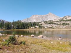 |
|||
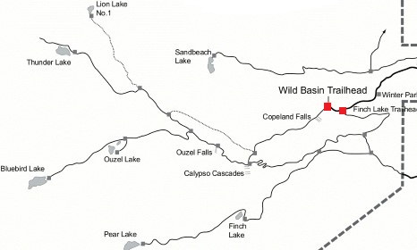
| Trail Location: | Wild Basin Trailhead | ||||
| Roundtrip Length: | 12.1 Miles | ||||
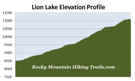
| Trailhead Elevation: | 8500 Feet | ||||
| Total Elevation Gain: | 2675 Feet | ||||
| Avg. Elev Gain / Mile: | 442 Feet | ||||
| Highest Elevation: | 11,110 Feet | ||||
| Trail Difficulty Rating: | 17.45 (strenuous) | ||||
| Parking Lot Latitude | 40.20777 | ||||
| Parking Lot Longitude | -105.56657 | ||||
Trail Description:
The hike to Lion Lake No. 1 begins from the fairly remote Wild Basin Trailhead in the southeastern corner of Rocky Mountain National Park, located near the small communities of Meeker Park and Allenspark. To reach the trailhead from Estes Park, drive 12.6 miles south on Colorado Highway 7 to the Wild Basin Road junction and turn right. After driving four-tenths of a mile, make another right turn into the park. The Wild Basin Trailhead is located roughly 2.2 miles from the park turn-off on a narrow gravel road, suitable for two-wheel drive vehicles.
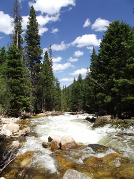
From the parking area the Wild Basin Trail begins by passing through a pristine subalpine forest. Lower Copeland Falls, your first destination along this route, arrives at roughly one-third of a mile from the trailhead. Upper Copeland Falls is located another tenth-of-a-mile further upstream along the North St. Vrain Creek. A short side trail visits both the lower and upper falls. This path runs parallel to the main trail, and once you've visited Upper Copeland Falls, will allow you to return back to the main trail without having to backtrack.
Just beyond the two waterfalls the trail crosses over Sandbeach Creek. At just over 1.3 miles hikers will reach the Pine Ridge Backcountry Campsite. Immediately past this site is a spur trail that provides access to a series of campgrounds. In all, the five backcountry campgrounds in this area offer a total of seven individual campsites.
 Although this spur trail is the shortest route to Lion Lake No. 1, it's a little bit more primitive, and a little bit more rugged than the main trail. The main route passes Calypso Cascades and Ouzel Falls, but adds almost another mile to your one-way destination. To continue towards Lion Lake via the shortest route, hikers should turn right at this junction.
For the most part this unimproved spur trail continues to follow the North St. Vrain Creek. At just over 1.6 miles hikers will arrive at the Tahosa Backcountry Campsite. At roughly 1.9 miles you'll pass the Aspen Knoll Backcountry Campsite, and at roughly 2.5 miles you'll reach the North St. Vrain Backcountry Campsite. The Thunder Lake Trail junction is also located here. To continue towards the lake hikers should turn right here. Just beyond this junction is the Siskin Backcountry Campsite.
At roughly 3.9 miles hikers will arrive at the Lion Lake Trail junction. Though the junction is clearly marked, it might be easy to miss if you’re not paying attention. The trail sign sits on an embankment above the main trail, and may be a bit harder to notice, especially since you’ll be ascending throughout this portion of the hike. The main trail continues to Thunder Lake. To proceed towards Lion Lake No. 1 you should turn right here.
From the junction the Lion Lake Trail climbs very steeply for a relatively short distance. The path is technically an unimproved trail, but is pretty easy to follow for the most part. There are a couple of rugged sections, but nothing out of the ordinary for Rocky Mountain National Park. The trail, however, travels over several rock slabs in some places, making it somewhat easy to lose the trail in these spots. Specifically, there are three short sections where you'll need to pay particularly close attention. One required a little bit of route finding. This spot arrives at roughly 4.6 miles from the trailhead. The trail effectively disappears into a slab of rock. Though your inclination might be to continue straight ahead at this point, you actually have to turn towards the left and proceed almost directly uphill. After roughly 15 yards or so you'll pick up the trail again.
At roughly 4.9 miles, just after the terrain begins to flatten for a short distance, hikers will pass a short side trail that leads to a scenic pond nestled off to the right.
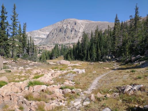
At roughly 5.75 miles the trail tops out once again. From here it begins a gentle descent through an incredibly beautiful meadow with massive boulders strewn about. As you proceed along this stretch Chiefs Head Peak rises above the trail, while Mt. Alice dominates the view on your left. While traversing across the meadow we spotted a ptarmigan off the side of the trail, as well as a small flock of mountain bluebirds skipping from tree to tree as we proceeded towards them.
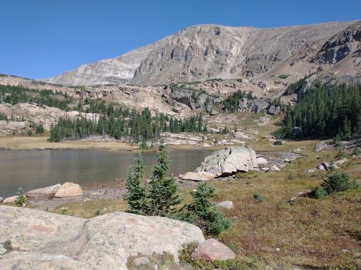
After soaking in the beautiful scenery at the meadow the trail makes a short ascent before descending back down to the lake. Hikers will finally arrive at the eastern shore of Lion Lake #1 at just over 6 miles from the trailhead. The rugged subalpine landscape that surrounds the lake offers some of the most beautiful scenery in the park. The lake is roughly 825 feet in length, has a surface area of roughly 7.5 acres, and appears to be very shallow – at least as far as you can see from the shore. Late spring and early summer hikers will also enjoy a plethora of wildflowers in this area. Be aware, however, that snow can also linger around at this elevation during this time period.

The prominent conical peak directly across the lake from this vantage point is 13,310-foot Mt. Alice, while Pilot Mountain extends off its left flank. Dominating the view towards the right is 13,579-foot Chiefs Head Peak, while 12,420-foot Tanima Peak dominates the view towards the south. This mountain rises directly above Thunder Lake.
As we sat there enjoying a well-earned lunch we watched a golden eagle soar along the updrafts above the eastern flank of Chiefs Head Peak. Much closer, we were treated to an American dipper bobbing along the rocks near the shore, and swimming through the water as it searched for food. If you’re lucky, you may even spot a wandering moose in this area.
For those who have the time and energy, an unmaintained trail circles around the north end of the basin. It eventually leads to Trio Falls, Lion Lake #2 and Snowbank Lake.