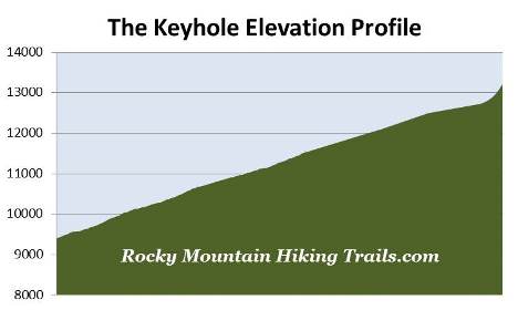
The Keyhole on Longs Peak
| Trail Features: | Outstanding views, Fall Aspens | 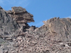 |
|||
| Trail Location: | Longs Peak Ranger Station | ||||
| Roundtrip Length: | 12.4 Miles | ||||
| Trailhead Elevation: | 9405 Feet | ||||
| Total Elevation Gain: | 3825 Feet | ||||
| Avg. Elev Gain / Mile: | 617 Feet | ||||
| Highest Elevation: | 13,200 Feet | ||||
| Trail Difficulty Rating: | 20.05 (strenuous) | ||||
| Parking Lot Latitude | 40.27215 | ||||
| Parking Lot Longitude | -105.55682 | ||||
Trail Description:
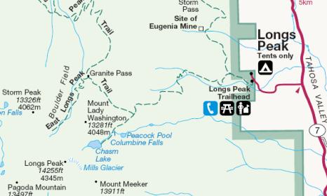
The hike to the Keyhole on Longs Peak begins from the Longs Peak Trailhead. To reach the trailhead from Estes Park, drive 8.9 miles south along Colorado Highway 7 to the turnoff for the Longs Peak Ranger Station. From the turnoff drive another mile to the ranger station. Please note that parking is fairly limited, and the lot fills up very early on weekends. Additional parking is available along the roadside leading up to the trailhead, but is also quite limited. You may also want to note that car-camping isn't allowed in the parking area.
Due to the popularity of the hikes from this trailhead, the length of time it takes to reach most destinations, exposure to afternoon thunderstorms, and limited parking, you'll definitely want to arrive as early in the morning as possible, especially on weekends during the summer months. Day hikers planning to summit Longs Peak usually arrive between 3 a.m. and 5 a.m.
Starting at an elevation of roughly 9405 feet, hikers will be following the East Longs Peak Trail for the entire route on this hike.
Longs Peak is the highest point in Rocky Mountain National Park. The 14,259-foot peak is named after Major Stephen H. Long who led an expedition across the Great Plains and along the base of the Rockies in 1820. While out on the plains, in the distant view, the expedition could see the highest mountain in the northern range. Although they never entered Rocky Mountain National Park, three members of the expedition would later become the first to climb Pikes Peak.
John Wesley Powell, along with several others including William Byers, the founder of Rocky Mountain News, made the first ascent of Longs Peak in 1868. Powell, the one-arm Civil War Major, was also the first person to float the Colorado River through the Grand Canyon.
For William Byers this was his second attempt at Longs Peak. After failing to reach the summit in 1864, he stated; "We are quite sure that no living creature, unless it had wings to fly, was ever upon its summit, and we believe we run no risk in predicting that no man ever will be, though it is barely possible the ascent can be made."
 From the Longs Peak Ranger Station the trail begins to climb steeply through a thick forest of lodgepole pine, spruce and fir. Roughly one-half mile from the trailhead hikers will reach the Eugenia Mine Trail junction, and at 1.2 miles will pass the short side trail that leads to the Goblins Forest Backcountry Campground (containing six individual
campsites).
From the Longs Peak Ranger Station the trail begins to climb steeply through a thick forest of lodgepole pine, spruce and fir. Roughly one-half mile from the trailhead hikers will reach the Eugenia Mine Trail junction, and at 1.2 miles will pass the short side trail that leads to the Goblins Forest Backcountry Campground (containing six individual
campsites).
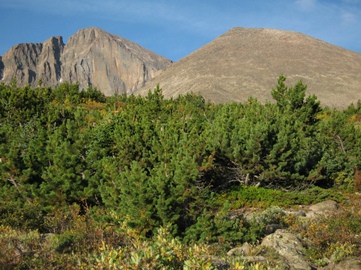
At 2.2 miles from the trailhead, and an elevation of roughly 10,750 feet, hikers will emerge from the forest and enter the subalpine zone. Dominating the landscape along this stretch of trail is krummholz, a German word that means twisted wood, which describes the stunted and irregular growth patterns of trees found in the transition zone between forest and tundra. Mt. Meeker, Longs Peak and Mt. Lady Washington will come into view at this point.
 At just over 2.5 miles you'll reach the spur trail that leads to the Battle Mountain Backcountry Campsite (contains one group campsite). Beyond the junction the main trail leaves the subalpine zone and begins to ascend Mills Moraine. Most hikers will likely benefit from the use of trekking poles as they travel along this rugged stretch of terrain.
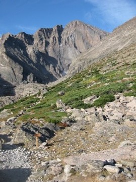
At roughly 3.4 miles, and an elevation of 11,540 feet, hikers will arrive at the Chasm Lake Trail junction. From this point 13,281-foot Mt. Lady Washington will be the dominating feature towards the west. Beyond the junction the trail makes a semi-circle around Mt. Lady Washington as it makes its way over to the Boulder Field. While traversing the northeastern slopes of Mt. Lady Washington, Battle Mountain will dominate the views towards the north.
At roughly 4.5 miles from the trailhead, and an elevation of 12,080 feet, hikers will reach the saddle between Mt. Lady Washington and Battle Mountain. Also located here at Granite Pass is the junction with the North Longs Peak Trail, which heads north towards its outlet at Glacier Gorge Junction. The trail leading to the Keyhole now begins heading in a southwesterly direction. Soon afterwards you'll begin hiking through the Boulder Field. Throughout this section rocks and boulders become increasingly larger, and travel becomes progressively more difficult as you'll be forced to do a little rock hopping in some places.
 At 5.9 miles hikers will reach the Boulder Field Backcountry Campground (containing nine individual campsites), which is one of the more unique campsites you'll see in a national park. Campers and/or the park service have built rock rings around the tent sites in order to help keep wind and blowing snow at bay. If needed, an outhouse is located here as well.
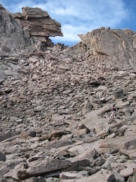
From the campground 13,326-foot Storm Peak will be the dominating feature towards the northwest. Longs Peak will lie directly towards the south, and in between is the famous notch known as "The Keyhole". Climbers wishing to summit Longs Peak via the Keyhole Route will pass through the notch (see photo below) in order to reach the west side of the ridge, which allows them to make the final 1.3-mile approach to the top.
Once past the campsite the real fun begins. Over the next third-of-a-mile the trail climbs roughly 500 feet. This is an extremely rugged section of "trail" that requires scrambling, use of hand-holds, rock hopping over boulders, and a great deal of route finding. Look closely and you'll see several cairns to help with navigation. As you proceed higher the terrain becomes progressively steeper and more difficult to climb. There's no real danger of falling off a cliff, but it would be very easy to break a bone or twist an ankle if not careful.
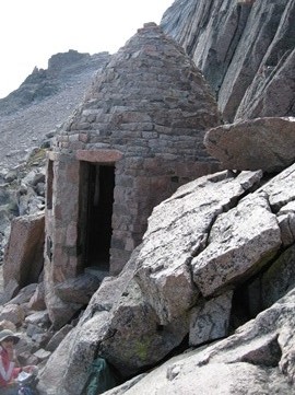
Just below the Keyhole is the Agnes Vaille Shelter, which was built as a memorial after Ms. Vaille died in this area shortly after becoming the first woman to climb Longs Peak in the winter. While making her descent on January 25, 1925, Vaille slipped and fell about 150 feet. Spent with fatigue, Vaille insisted she needed a short nap, but froze to death before her hiking partner could bring back help. Today the memorial serves as a refuge for hikers in need.
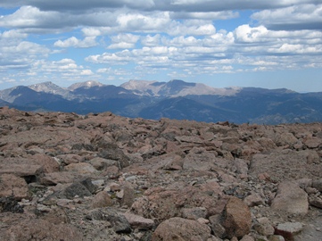
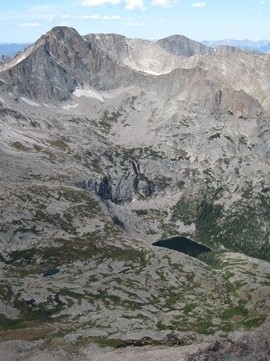 After hiking 6.2 miles and climbing more than 3800 feet, hikers will finally reach the Keyhole, which sits at an elevation of 13,200 feet. Looking out from the other side of the ridge you'll have outstanding views of Powell Peak, McHenry Peak, Glacier Gorge and Black Lake.
This is an extremely difficult hike – perhaps the most difficult hike I've ever done. In addition to the length and the amount of elevation gain, the rugged terrain makes for a very long and tiring day.
Beyond the Keyhole the trail becomes a bit more technical with "moderate" (frightening from my standpoint) exposure. The 1.3-mile Keyhole Route is considered to be a climb - a classic mountaineering route that should not be underestimated. It crosses enormous vertical rock faces, has narrow ledges, is exposed to falling rock, and requires scrambling on all fours in some places. Climbers can encounter snow and ice at any time of the year. The terrain requires route finding skills and the ability to assess and adjust to unexpected or changing weather conditions. As the Rocky Mountain National Park website warns, "a slip, trip or fall could be fatal" along this route.
The national park website provides additional information on hiking in the Longs Peak area, as well as general hazards you should be aware of while hiking in the high country. Hikers should always be aware of lightning risk while hiking in the Rocky Mountains, especially at higher elevations. As a general rule of thumb you should plan to be off the summit before noon in order to avoid the notorious afternoon thunderstorms that frequent the Rockies during the summer months. Hikers should also be prepared for extreme sun exposure, wind, cool temperatures, and rapidly changing weather conditions while on the trail. Make sure you have the proper gear with you, and know what safety precautions you need to consider beforehand.