
Mills Lake
| Trail Features: | Outstanding Lake Views, Waterfalls | 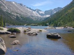 |
|||
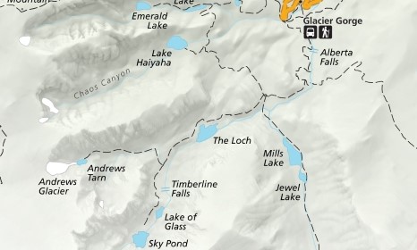
| Trail Location: | Glacier Gorge | ||||
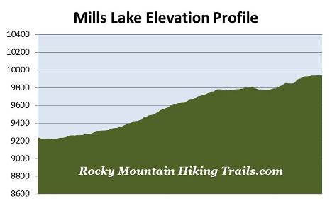
| Roundtrip Length: | 5.3 Miles | ||||
| Trailhead Elevation: | 9240 Feet | ||||
| Total Elevation Gain: | 780 Feet | ||||
| Avg. Elev Gain / Mile: | 295 Feet | ||||
| Highest Elevation: | 9940 Feet | ||||
| Trail Difficulty Rating: | 6.84 (moderate) | ||||
| Parking Lot Latitude | 40.31035 | ||||
| Parking Lot Longitude | -105.64038 | ||||
Trail Description:
The hike to Mills Lake in Rocky Mountain National Park begins from the Glacier Gorge Trailhead, located on Bear Lake Road almost 8 miles from the turn-off at Highway 36. Due to the extreme popularity of the Bear Lake Road area you may want to consider using the free park shuttle to access the trailhead during peak tourist season. Hikers will also have the option of starting their hike from the Bear Lake Trailhead. This will add another two-tenths of a mile to your overall roundtrip mileage.
Roughly one-quarter of a mile from the parking area, just after crossing Chaos Creek, the trail briefly converges with the Glacier Creek Trail. After walking a very short distance the Glacier Creek Trail splits off to the right and heads toward Bear Lake. To continue on towards Mills Lake hikers should turn left at this junction.
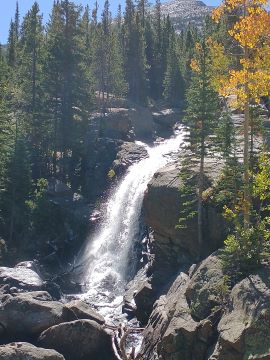 At just over eight-tenths of a mile hikers will reach Alberta Falls, one of the more popular hiking destinations in the park. This scenic 30-foot waterfall thunders down a small gorge on Glacier Creek, and is named after Alberta Sprague, the wife of Abner Sprague, one of the original settlers in the Estes Park area.
The next section of trail, between Alberta Falls and Mills Junction, was rehabilitated by the National Park Service and the Rocky Mountain Conservancy as part of a major, multi-year project that was completed in 2012.
At 1.6 miles hikers will arrive at the North Longs Peak Trail junction. To continue on towards your destination hikers should turn right here.
About a half-mile further up the trail you'll reach Mills Junction. Straight ahead is the Loch Vale Trail which leads to The Loch and Sky Pond, while the side trail branching off to the right leads up to Lake Haiyaha. As part of the same trail rehabilitation project, this unimproved route was also upgraded in an effort to make it safer and easier to follow as it travels towards the lake.
To continue on towards Mills Lake hikers should turn left at this junction. After a short distance the trail crosses over Vale Brook, at which point you'll enter the majestic Glacier Gorge.
At 2.4 miles you'll cross over Glacier Creek. Just before crossing the footbridge you might notice a faint social trail on your right. After walking roughly 40 yards along this path you'll reach the base of a small waterfall known as Glacier Falls.
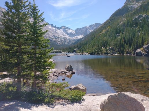
At just over 2.6 miles hikers will reach the foot of Mills Lake, a beautiful subalpine lake nestled just below Half Mountain. From its eastern shore, looking from left to right, you'll have outstanding views of the Keyboard of the Winds, 13,497-foot Pagoda Mountain, 13,579-foot Chiefs Head Peak and 12,668-foot Thatchtop Mountain. A fairly large rocky area along the edge of the lake makes this a great location for a picnic.
"In years to come when I am asleep beneath the pines, thousands of families will find rest and hope in this park." - Enos Mills
The lake is named for Enos Mills, the man commonly referred to as the "father of Rocky Mountain National Park". Mills became the area's first naturalist, and made great contributions to the field that would eventually lead to the profession of interpretive park rangers. He also established a guide service that led tourists to the summit of Longs Peak. At the age of 15 he made his first ascent of the park's highest peak, and over the course of his life would make the trip 40 times by himself, and nearly 300 times as a guide.
His most significant contribution, however, was spending numerous years lecturing across the nation, lobbying Congress, and writing thousands of letters and articles that would eventually lead to the creation of Rocky Mountain National Park on January 26, 1915.
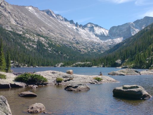
From the northern shore the trail skirts around the east side of the lake, and in my opinion, provides even better photo opportunities. You can also continue for another half-mile along the easy route to visit Jewel Lake, which also offers some great photo opportunities. Another 1.7 miles further up the trail is Black Lake.
For backpackers looking to camp in the area, the Glacier Gorge Backcountry Campsite (one site) is located almost a half-mile above Jewell Lake. This is the only campsite in the Glacier Gorge area.