Andrews Tarn
| Trail Features: | Alpine Lake, Glacier | 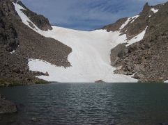 |
|||
| Trail Location: | Glacier Gorge | ||||
| Roundtrip Length: | 9.3 Miles | ||||
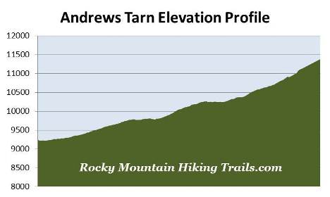
| Trailhead Elevation: | 9240 Feet | ||||
| Total Elevation Gain: | 2300 Feet | ||||
| Avg. Elev Gain / Mile: | 495 Feet | ||||
| Highest Elevation: | 11,380 Feet | ||||
| Trail Difficulty Rating: | 13.9 (strenuous) | ||||
| Parking Lot Latitude | 40.31035 | ||||
| Parking Lot Longitude | -105.64038 | ||||
Trail Description:
I don't want to sound like Bill Bryson here, but we never made it to Andrews Tarn. I hiked the Andrews Glacier Trail for the first time with a group of friends in 2012. We made it deep into the canyon, but lost the trail and went far too low. In addition to a very faint trail, the glacier isn't visible from anywhere in the canyon, thus denying hikers the use of a guidepost. Speaking with a ranger afterwards we confirmed that the tarn and glacier are hidden behind a flank on Otis Peak. The following is a hike description based on how far we made it that day (roughly one-quarter of a mile shy of the tarn).
The hike to Andrews Tarn in Rocky Mountain National Park begins from the Glacier Gorge Trailhead, located on Bear Lake Road almost eight miles from the turn-off at Highway 36. Due to the extreme popularity of the Bear Lake Road area you may want to consider using the free park shuttle system to reach the trailhead during peak tourist season. Hikers will also have the option of starting their hike from the Bear Lake Trailhead. This will add another two-tenths of a mile to your overall roundtrip mileage.
Roughly one-quarter of a mile from the parking area, just after crossing Chaos Creek, the trail briefly converges with the Glacier Creek Trail. After walking a very short distance the Glacier Creek Trail splits off to the right and heads toward Bear Lake. To continue towards Andrews Tarn hikers should turn left at this junction.
At just over eight-tenths of a mile hikers will reach Alberta Falls, one of the more popular hiking destinations in Rocky Mountain National Park. This scenic 30-foot waterfall thunders down a small gorge on Glacier Creek, and is named after Alberta Sprague, the wife of Abner Sprague, one of the original settlers in the Estes Park area.
The next section of trail, between Alberta Falls and Mills Junction, was rehabilitated by the National Park Service and the Rocky Mountain Conservancy as part of a major, multi-year project that was completed in 2012.
At 1.6 miles hikers will arrive at the North Longs Peak Trail junction. To continue towards Andrews Tarn hikers should turn right here.
About a half-mile further up the trail you'll reach Mills Junction. The trail to the left leads to Mills Lake and Black Lake, while the trail to the right leads to Lake Haiyaha. As part of the same rehabilitation project, this unimproved route was also upgraded in an effort to make it safer and easier to follow as it travels towards the lake.
To continue towards Andrews Tarn you should proceed straight ahead onto the Loch Vale Trail.
Above the junction the route becomes quite steep as it climbs a couple of short switchbacks through a fairly impressive gorge, while Icy Brook cascades down the valley on your left. On the third switchback you'll reach a vantage point that offers a nice view of a waterfall tumbling down the gorge.
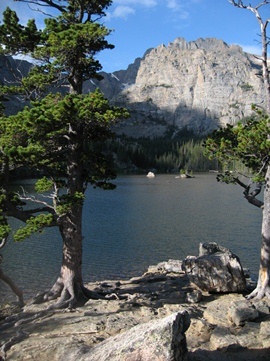 At roughly 2.8 miles hikers will reach Loch Vale, better known as The Loch. This beautiful subalpine lake, situated at 10,190 feet, is located within one of the most studied watersheds in the world. For more than forty years scientists have monitored chemical inputs into the watershed, from wind and precipitation, in order to distinguish between human impacts and natural processes occurring in this environment.
Dominating the views directly across the foot of The Loch is 13,153-foot Taylor Peak and Taylor Glacier. Framing the gorge on either side is 12,668-foot Thatchtop Mountain and The Sharkstooth. As you proceed around the north shore of the lake 13,208-foot Powell Peak will begin to reveal itself towards the south.
The word "Loch" is the Scottish Gaelic and Irish term for a lake or a sea inlet.
Beyond the lake the trail begins to climb again, and at just over 3.6 miles from the trailhead you’ll reach the Sky Pond / Andrews Glacier Trail split. The trail to the left leads to Timberline Falls and Sky Pond, while the Andrews Glacier Trail leads uphill towards the right.
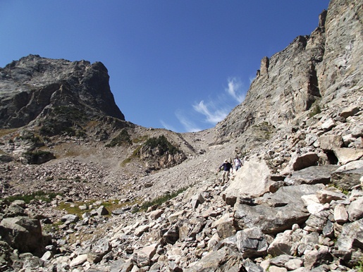
Just beyond the spilt is the Andrews Creek Backcountry Campsite, the only campsite in this area of the park. Roughly one-tenth of a mile above the campground is a somewhat confusing series of social trails that lead through a section of downed trees. Take the most obvious line through this section, or continue heading towards the spires and soon you'll be out in the open where the trail is more clearly visible. Just after crossing Andrews Creek, however, the trail becomes progressively more rugged. Route finding also becomes more difficult. In many places you'll be looking for cairns in the scree and talus to help guide the way. I highly recommend taking trekking poles with you on this hike.
At roughly 4.25 miles from the trailhead, somehow or another our party got off the main trail and began following a faint trail that took us low into the canyon. As we got closer to the end of the canyon I decided to climb up to what appeared to be a flat spot, roughly 200 feet above, where I thought the tarn might be located. I obviously struck out with that plan.
By this time I had reached an elevation of 11,120 feet. Looking at my data now I had another 260 feet, and at least another quarter-mile of off-trail climbing to make it to the now obvious location of the tarn. However, after visiting Sky Pond earlier in our hike, my hiking partners had already given up, and I was already pretty exhausted myself. It wasn't until I started descending that I came across the main trail and confirmed that we had gone far too low into the canyon.
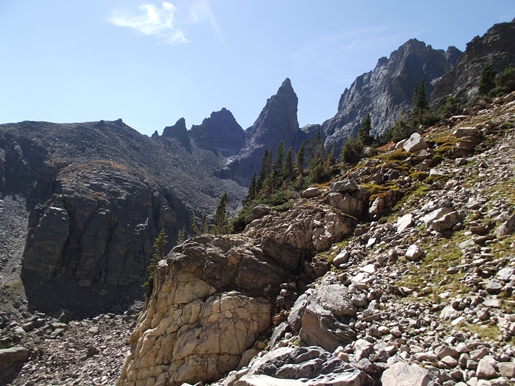
From my furthest point into the canyon I still had an awesome view of The Sharkstooth:
The photo below shows the location of Andrews Tarn and Andrews Glacier. At the bottom of the U is the location of the tarn, while the glacier sits behind the wall on the right. As you can see, the terrain leading to the tarn is quite rugged:
In hindsight, I would say that the Andrews Glacier Trail portion of this hike could be considered more of a mountaineering route than a conventional hike. If I were to ever attempt this again I would definitely start early in the morning on a day when great weather is expected. Also, I would say that you should probably have some basic mountaineering skills before attempting this hike.
You should also note that climbing on and around Andrews Glacier can be very dangerous. A man was killed in the summer of 2012 after sliding more than a hundred feet down the glacier.
Both Andrews Glacier and Tarn are named after Edwin B. Andrews, a relative of Abner Sprague. After the two men climbed it in 1897, Sprague would name the glacier after his brother-in-law.