Lily Mountain
| Trail Features: | Panoramic Views | 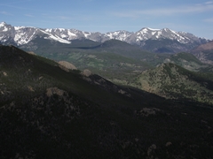 |
|||
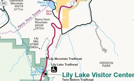
| Trail Location: | Lily Mountain Trailhead | ||||
| Roundtrip Length: | 4.0 Miles | ||||
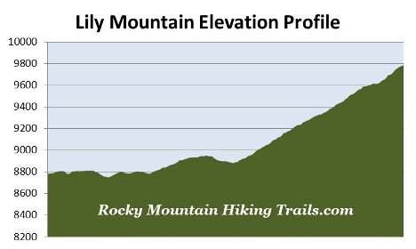
| Trailhead Elevation: | 8780 Feet | ||||
| Total Elevation Gain: | 1180 Feet | ||||
| Avg. Elev Gain / Mile: | 590 Feet | ||||
| Highest Elevation: | 9786 Feet | ||||
| Trail Difficulty Rating: | 6.36 (moderate) | ||||
| Parking Lot Latitude | 40.31374 | ||||
| Parking Lot Longitude | -105.53533 | ||||
Trail Description:
The Lily Mountain Trailhead is located roughly 5.8 miles south of Estes Park on Colorado Highway 7. There are small parking areas located on both sides of the road near the trailhead. If full, you can park at the Lily Lake parking lot, located roughly a quarter-mile to the south, and then walk back along the busy highway to the trailhead. Please note that it's very easy to drive past the trailhead when coming from Estes Park, as the trailhead marker is nearly impossible to see when traveling southbound.
 Hikers may also want to note that the entire trail travels through the Roosevelt National Forest. Although not in the national park, the Lily Mountain Trail does appear on the official park map, as well as the National Geographic Trails Illustrated Map for Rocky Mountain National Park.
The trail starts off by following along the ridge just above Highway 7. Throughout this stretch you’ll enjoy sporadic views of the Estes Park area.
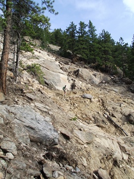
At roughly four-tenths of a mile from the trailhead hikers will reach an area that received substantial damage during the September 2013 flood, including a massive landslide that created a large scar down the mountainside. As a result, the trail was closed through June of 2014 while crews rebuilt the route through the washout area. This short section of trail, however, is easy to navigate through, and shouldn't pose a problem for anyone.
During that historic storm Estes Park received 9.4 inches of rain, while a gauge just south of Marys Lake reported 11.5 inches. The storm knocked out roads and bridges, stranded residents, and killed eight people in the Front Range area. Rocky Mountain National Park also received significant damage to roads, bridges and trails, which kept most of the park closed for almost two weeks.
After traveling over mostly flat terrain the trail finally begins ascending the mountain roughly six-tenths of a mile from the trailhead. At just over a mile the trail makes a sharp turn to the left, and begins heading in a southwesterly direction. As the path climbs higher it becomes progressively steeper, and the terrain becomes more rugged. Hikers will also have to negotiate around numerous rocks and boulders along the upper portions of the mountain. Fortunately, almost the entire route passes through a fairly dense evergreen forest, which will offer late morning hikers a nice respite from the rising sun.
At roughly 1.9 miles, as you near the top of the mountain, the trail becomes a little harder to read. There are cairns to help guide the way, and there's a sign posted on a tree that indicates the direction you should proceed. This last section of trail more or less becomes a scramble. You'll be using all fours to reach the summit in some places, but for the most part it's relatively safe, with very little exposure to steep drop-offs; provided you take your time and are careful. If you have an extreme fear of heights you may not want to do this hike. However, I can say for certain that it's well worth the effort.
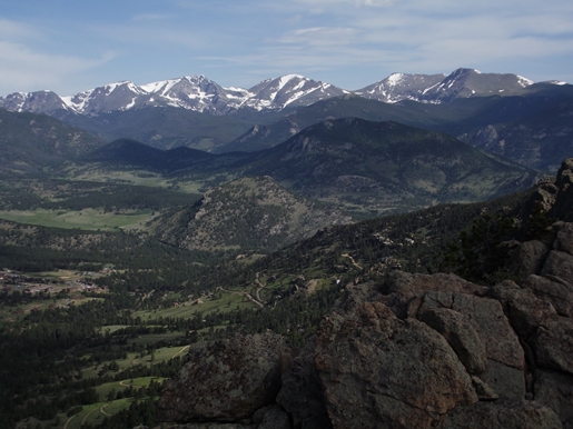
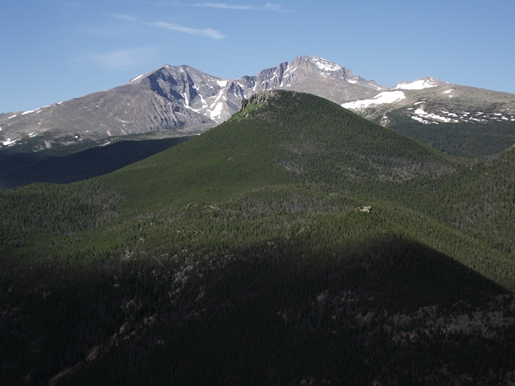
Although the Lily Mountain Trail isn't in the national park, it may as well be. Almost everything you can see from the summit is in Rocky Mountain National Park. Hikers will enjoy outstanding panoramic views of Mount Meeker, Longs Peak, Estes Cone and Twin Sisters Peak, as well as the mountains along the Continental Divide and in the Mummy Range. In a word, the 360-degree views from the summit are quite spectacular.