
Lizard Head Overlook
| Trail Features: | Scenic Views, Fall Aspens | 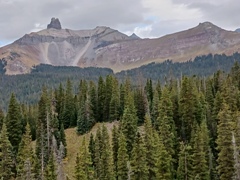 |
|||
| Trail Location: | Lizard Head Pass | ||||
| Roundtrip Length: | 5.5 Miles | ||||
| Trailhead Elevation: | 10,245 Feet | ||||
| Total Elevation Gain: | 1475 Feet | ||||
| Avg. Elev Gain / Mile: | 536 Feet | ||||
| Highest Elevation: | 10,800 Feet | ||||
| Trail Difficulty Rating: | 8.45 (moderate) | ||||
| Parking Lot Latitude | 37.81253 | ||||
| Parking Lot Longitude | -107.90847 | ||||
Trail Description:
The hike to the Lizard Head Overlook begins from the top of Lizard Head Pass near Telluride, Colorado. To reach the pass, drive south from the traffic circle near Telluride on Colorado Highway 145 for 11.7 miles. On the right (west) side of the highway is a large rest area. Although you can access the trail from the northeast corner of the parking area, the official trailhead is located in a smaller lot immediately above the main parking area. Simply drive through the large parking area, past the restroom, and turn right to access the Lizard Head Trailhead parking lot.
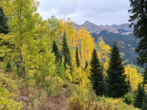
The hike begins by traveling northeast through an open grassy field for almost a half-mile before entering the canopy of a thick spruce-fir forest. Eventually the trail begins passing through a long stretch of mature aspen groves, making this an excellent choice for a fall hike.
At 1.6 miles hikers will enter the Lizard Head Wilderness. Up to this point the Lizard Head Trail has mostly traveled over a gentle grade, with a few mild undulations along the route. This portion of the trail more or less follows along the contours above Highway 145. After passing the wilderness boundary, however, the trail begins to ascend along the eastern slopes of Black Face Mountain, while traveling away from the highway. After ascending a series of switchbacks, views of Trout Lake in the valley below begin to open up.
As the trail climbs higher, hikers will travel along the periphery of forest and talus meadows. At just over 2.25 miles you’ll reach the side trail that leads to Wilson Meadows. The Lizard Head Trail proceeds towards the left to continue ascending Black Face Mountain. To reach the Lizard Head Overlook you should stay right at this junction and proceed along Wilson Meadows Trail.
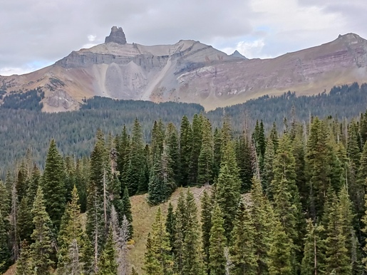
Just beyond the junction the trail passes a small pond just off the left side of the path. From here the trail travels along gentle grades while passing through a beautiful spruce forest. Roughly a half mile beyond the junction you’ll reach an overlook that provides an outstanding view of Lizard Head Peak. This 13,113-foot mountain is topped by a 400-foot volcanic spire of rotten, crumbling rock that, according to the San Juan National Forest website, has been voted as one of Colorado's most dangerous and difficult climbs.
Truth be told, we intended to hike to Wilson Meadows, but lost the correct route at this point. The main trail appears to continue towards the right of the overlook, and almost immediately proceeds up a steep hill. After traveling more than a quarter mile up this hill we realized this didn’t fit the descriptions of the route or the topography of the map. So, we returned to the overlook and discovered a sign pole nearby. This appeared to hold a trail sign at one point. It also appeared that a trail branched off to the left here, and began descending a dark clay embankment. However, after a short distance the trail disappeared into the mud bank. Moreover, we didn’t see any evidence that a trail continued beyond the mud slide, or in the valley below. As a result, we decided to end this hike at the overlook. This vantage point, after all, offers hikers a great chance to see the Lizard Head without climbing all the way to the summit of Black Face Mountain.
Additional Resources:
* Trails Illustrated Map for Telluride, Silverton, Ouray and Lake City areas