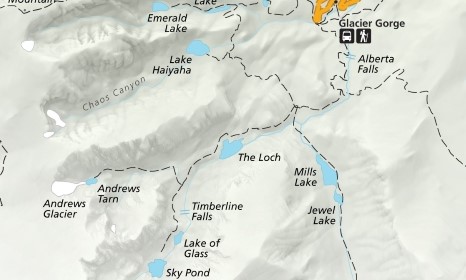
The Loch
| Trail Features: | Outstanding Lake Views, Waterfalls | 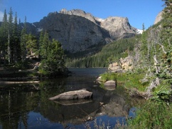 |
|||
| Trail Location: | Glacier Gorge | ||||
| Roundtrip Length: | 5.7 Miles | ||||
| Trailhead Elevation: | 9240 Feet | ||||
| Total Elevation Gain: | 1040 Feet | ||||
| Avg. Elev Gain / Mile: | 367 Feet | ||||
| Highest Elevation: | 10,190 Feet | ||||
| Trail Difficulty Rating: | 7.74 (moderate) | ||||
| Parking Lot Latitude | 40.31035 | ||||
| Parking Lot Longitude | -105.64038 | ||||
Trail Description:
The hike to The Loch in Rocky Mountain National Park begins from the Glacier Gorge Trailhead, located on Bear Lake Road almost 8 miles from the turn-off at Highway 36. Due to the extreme popularity of the Bear Lake Road area you may want to consider using the free park shuttle to access the trailhead during peak season. Hikers will also have the option of starting their hike from the Bear Lake Trailhead. This will add another two-tenths of a mile to your overall roundtrip mileage.
Roughly one-quarter of a mile from the parking area, just after crossing Chaos Creek, the trail briefly converges with the Glacier Creek Trail. After walking a very short distance the Glacier Creek Trail splits off to the right and heads toward Bear Lake. To continue towards The Loch hikers should turn left at this junction.
 At just over eight-tenths of a mile hikers will reach Alberta Falls, one of the more popular hiking destinations in Rocky Mountain National Park. This scenic 30-foot waterfall thunders down a small gorge on Glacier Creek, and is named after Alberta Sprague, the wife of Abner Sprague, one of the first settlers in the Estes Park area.
The next section of trail, between Alberta Falls and Mills Junction, was rehabilitated by the National Park Service and the Rocky Mountain Conservancy as part of a major, multi-year project that was completed in 2012.
At 1.6 miles hikers will arrive at the North Longs Peak Trail junction. To continue towards your destination hikers should turn right here.
About a half-mile further up the trail you'll reach Mills Junction. The trail to the left leads to Mills Lake and Black Lake, while the trail to the right leads up to Lake Haiyaha. As part of the same trail rehabilitation project, this unimproved route was also upgraded in an effort to make it safer and easier to follow as it travels towards the lake.
 To continue towards The Loch hikers should proceed straight ahead onto the Loch Vale Trail.
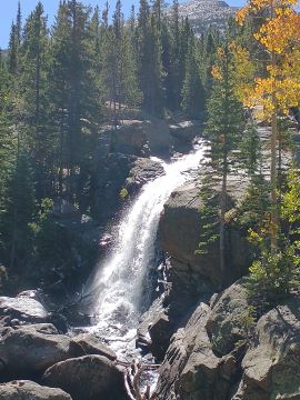
Above the junction the route becomes quite steep as it climbs over a couple of short switchbacks through a fairly impressive gorge, while Icy Brook cascades down the valley on your left. On the third switchback you'll reach a vantage point that offers a nice view of a waterfall tumbling down the gorge.
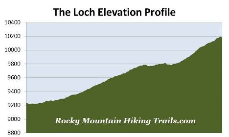
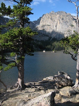
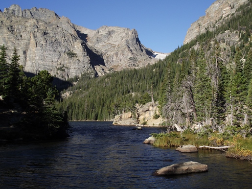
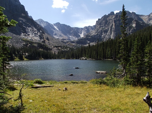
At roughly 2.8 miles hikers will reach Loch Vale, better known as The Loch. This beautiful subalpine lake, situated at 10,190 feet, is located within one of the most studied watersheds in the world. For more than forty years scientists have monitored chemical inputs into the watershed, from wind and precipitation, in order to distinguish between human impacts and natural processes occurring in this environment.
Dominating the views directly across from the foot of the lake is 13,153-foot Taylor Peak and Taylor Glacier. Framing the spectacular gorge on either side is 12,668-foot Thatchtop Mountain towards the south, and 12,829-foot The Sharkstooth towards the southwest. If you were to proceed around to the north side of the lake 13,208-foot Powell Peak will begin to reveal itself towards the south.
In case you're wondering, the word "Loch" is the Scottish Gaelic and Irish term for a lake or a sea inlet.
If you wish to explore more of the terrain in this part of the park you'll have the option of continuing up to Timberline Falls, Sky Pond or even Andrews Tarn.